Copyright © 2024 Continental Book Company.
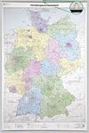
MapsOur political and physical wall maps are a great addition to your class. Political maps show country boundaries, major bodies of water, cities and towns, and highways. They are laminated on both sides using 3mm hot lamination, which protects your wall map and allows you to write on it with dry-erase markers. Wooden Rails are available for some of the maps and will add a warm, classic look. A solid cherry-stained wooden rail is soundly attached to the top and bottom of your map, and a rugged cord makes it easy to hang.
|
Copyright © 2024 Continental Book Company.


